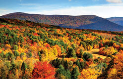
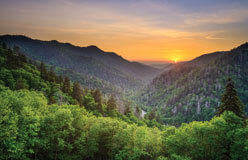
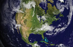
Leaving the mountains and deep thick forests, you come to the Central Plains.
Trees grow across the rolling hills. Wildflowers are in bloom along the roadsides. Lakes and rivers dot the landscape, which might make you want to go for a swim. You're in luck! This is the Great Lakes region of the Central Plains. Here’s where you’ll find the country’s biggest lake. Beyond this region to the west lies the mighty Mississippi River, which grows bigger and wider as it travels south to the Gulf of Mexico. Follow the sounds of water as you explore the Central Plains.


▲ Ontario, Erie, Huron, Michigan, and Superior are the five Great Lakes. They’re not the only bodies of water in the Great Lakes system. They’re connected by rivers, straits (narrow passages of water), and even a smaller lake. Together, they make up the largest freshwater system on Earth! Freshwater is less salty than seawater. Fishing and shipping industries rely on these connected waterways.

▲ A lake's size isn't the only thing that makes it "great." The Great Lakes have been supporting various life forms since they first started forming nearly 14,000 years ago. At that time, an enormous glacier covered the region. When the Ice Age ended and the glacier melted, many bodies of water remained behind. People have been living in the Great Lakes area for about 10,000 years. Plants, animals, fish, and birds thrive along the shores. One of the five, Lake Superior, is this country’s biggest. Each of the five Great Lakes is so big that it's visible from space.

▲ In the Central Plains, the lakes and rivers are full of fish. Birds that feed on those fish make nests along the banks. The water attracts other animals, too, like deer, squirrels, and rabbits. They come to drink, while foxes, wolves, and bears come to drink and eat other animals. Of course, beavers love water, too. Deciduous forests, where leaves fall off the trees in winter, cover hills and plains. Crops, fruit trees, bushes, ferns, and grasses grow in the fertile soil.

▲ The Mississippi is the second-longest river in North America. Its source, or where it begins, is Lake Itasca in Minnesota. The Mississippi empties into the Gulf of Mexico in Louisiana. That’s called its mouth, or where a river ends. Rivers from 31 states and two Canadian provinces flow into the Mississippi River system. Rivers that empty into other rivers are called tributaries. At its widest point, the Mississippi River is 11 miles across.

◀ The water in the Great Lakes affects the region’s weather. Imagine cold air passing over warm lake water. The cold air acts like a big sponge, soaking up water from the lake. Later, it wrings that water out over land. That's called lake-effect snow. It happens most often in late fall to early winter, before all the lakes are frozen. In October 2006, Buffalo, New York, got more than 22 inches of lake-effect snow in just 16 hours!
Think Piece!
Major cities grew on the shores of the Great Lakes waterways and the Mississippi River. Why do you think people built cities on waterways?

The country’s tall mountains and wide plains inspired pioneers to tell “tall tales.” People made up these exaggerated stories for fun. Many were about a very tall lumberjack named Paul Bunyan. He was said to travel with a huge blue ox named Babe. The tales told how Paul and Babe created the landscape. For example, when Babe was thirsty, Paul dug her watering holes that became the Great Lakes. Walking through Minnesota, their footprints left behind 10,000 lakes. And how did Paul create Mount Hood all by himself? By piling rocks on his campfire to put it out, of course!