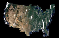
If you could float above the Earth and look down on the United States, this is what you might see.
This image was made using information from a type of human-made satellite called Landsat. A human-made satellite is an object sent into space. It orbits the Earth and sends back information. Landsat measures light reflected off the Earth from the sun. Hundreds of small scenes were stitched together. Scientists also added information about elevation. The result: this spectacular image that shows how varied the land across the United States is.